Description
Buy two for a 50% discount on the second map and combined shipping. Contact quietwest@yahoo.com
This beautiful collector’s map of the west coast has a story:
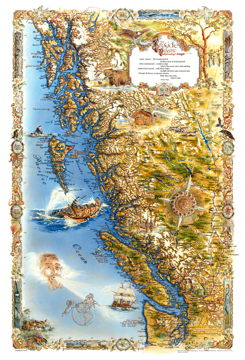
The Inside Passage Map is a soulful and romantic map integrating cartography, poetry, visual art, historical research, inspiration, nature and different cultures of people.
A unique portrayal of the west coast has been created. The goal was to create a beautiful collector’s map with a diverse range of information and ideas.
At the heart of the map is the desire to bring recognition and appreciation for the power and harmony within lyric poetry – by bringing it to you alive – as art.
Points of Interest
The Border – Intricate and full of detail, the design alternates between panoramic west coast scenery and flowers, with sea life weaved in between. The decorative cameos, which are centered in the border, contain ghosted flowers and verse. This tiny poem is referred to as the “rhyming riddle”. If you follow the rhyme of each line within each cameo, you will be able to figure out the correct order of the verse. It was originally written as a twelve-line poem. It captures the overall theme and design of the map.
The Legend Box – The legend box gives the title and the main poem, which together, create a parallel between both the outer and inner conditions that we face in our lives. The third line of the poem refers to tragedy and death (swallows sleep). Wind O’less means windowless and refers to the inner person. Inside of ourselves – unseen by other people, the waves of emotion, the cycles of despair, and contractions of grief are compared to the waves of the ocean in force and rhythm. The Inside Passage poem was born of this understanding. It is a sequel to grief-written poems called Lunar Tunes and Window Pain.
The Quiet-West Crest – The bottom center of the legend box is a crest designed to visually express the profile and goals of Quiet West Publishing. Firstly it contains a scrolled map to represent the historical BC coastal collector’s map concept. An open book contains reductions of actual stained glass windows with images of ladies wearing brimmed hats. Above the book a paintbrush and pen are crossed, combining the literary and visual arts. The rising sun represents the hope we have for each tomorrow.
Cartouches – The eagle, sighted frequently along the west coast is shown flying down to her nest and represents responsibilities to future generations. The bear, shown to the left of the legend box, is near Tatshenshini – Alsek Park. This region, which is home to countless species of wildlife, is one of the most important protected wilderness parks in the world. To the left of the compass rose, there is a scene depicting trade between the European and Haida people. The costumes, along with the illustration of the Haida settlement in the background are historically and culturally representative. The Nuu-chal-nuth people are featured in the whaling expedition scene. This dramatic cartouche was placed in close proximity to Quatsino Sound, the historical whaling harbor on northern Vancouver Island. The face in the wind represents the stormy and treacherous conditions on western Vancouver Island and the Olympic Peninsula. Cherubs hover over the globe to show the location of the Inside Passage and to represent a stylistic feature commonly used on seventeenth century maps.
The Compass Rose – The interesting and elaborate compass rose design was created by placing a borrowed seventeenth century brooch on a hand-made European lace doily. The brooch was brought to Canada by Scandinavian war bride Elinor Thun. She wrote the description as follows: “This particular brooch is more than eight hundred years old, and came from a western fjord in Norway at Siem, near Bergen from the maternal side of my family. It is known in Norwegian as “solje or kappe-brosje”. Brooches of these types were used by men and women to hold their capes in place. Jewelry of the day was worn as an expression of wealth, and would sometimes be given as gifts from one king to another. The Vikings were great travellers and the designs show an eastern flair which would eventually weave itself into the culture of the Norse-lands.” Elinor Thun Ueland 1994.
Cartography – The map was created by using an extensive amount of historical reference material, by translating poems into images – and by merging art with technology. Land contours and shoreline details were carefully blended to create emphasis and depth. Mossy greens, white mountain peaks, rich earth tones, hand lettered names, and locations of notable shipwrecks bring harmony and intrigue into the map.
Whether your interests are philosophical or artistic, this map demonstrates originality and lasting value. It is a truly great work – to honour one of the most beautiful places in the world.
Published by Quiet West Publishing & Marketing in 1993.
Copyright Valerie J. Hayes and Quiet West (2021). Unauthorised use and/or duplication of this material without express and written permission from this blog’s author/owner is strictly prohibited. Excerpts and links may be used, provided that full and clear credit is given to Valerie J. Hayes and Quiet West with appropriate and specific direction to the original content.


